 I’m not the fastest to catch on to new technologies, but I do my best. That’s why this may not be news to some of you.
But the other day while doing some research for a course review, I stumbled onto some golf-specific uses for Google Earth that I thought were very, very cool. Unfortunately, the course you’re looking for has to be in an area they display in high resolution.
But if it is, from creating your own yardage book to understanding why your approach to that uphill par 3 always seems to come up short, this free net-based program can help you scope courses you play all the time and some you wish you could.
The Program
I’ll refrain from going into all the program’s features. There’s a ton of fun and information. If you haven’t yet used Google Map or the satellite images on MapQuest, just let me say that the images from space are so good they are spooky.
Just as a for instance, I can pick out my brother’s car in his driveway.
I’ve long used Google and MapQuest to get directions and scout my driving route. Google Earth, however, adds another dimension, especially when it comes to golf.
The link to the home page gets you started. But be warned. This is a hefty streaming net-based program requiring both a fairly fast computer and a fast connection. I’ve got a cable connection and am running a PowerBook with a 1.5 GHz processor and 512 of SDRAM and I’m stretching things. It’s not lightning fast. So be warned.
Fun Things to Try
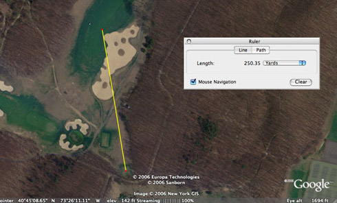
Two capabilities in the program beg for golf applications. The first is a “ruler” that lets you measure in yards. Once you’ve zoomed in on a course, you can measure distances to hazards, greens, whatever. You can also use it to measure how far you’ve hit your drive on certain holes. And that can be a real eye-opener.

How far is it to carry the cross bunker from the back tee at Bethpage Black’s 7th hole? On this line, it’s a good 250 yards.
Just for kicks, I measured some drives I’d hit 20 years ago with a persimmon driver on a course I played a lot. Amazingly, they were just about the same distance I’m hitting drives today with my graphite-powered titanium bomber.
I also measured distances at a driving range I used to frequent regularly. Again, a real eye opener on the realities of how far I’m actually hitting certain clubs.
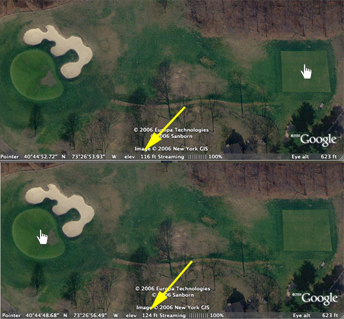
The other thing you can do is measure elevations. Just put the cursor over a spot and it will give you the elevation above sea level. Move it to another spot and you can figure the elevation change.

The 14th hole at Bethpage Black is very deceiving due to the deep valley between tee and green. With the elevation feature in Google Earth, however, you can tell the green is about 8 feet higher than the tee… or about one club more. Just move the hand cursor over a spot and it shows the height above sea level.
One word of caution on this feature, however. I measured some elevation changes that just didn’t seem right to me. For instance, the 15th green on the Bethpage Black course seems to tower in the sky, but Google Earth only showed something like a 10-foot elevation change from the fairway to the green. It sure seems higher than that.
Limitations
As I mentioned in the beginning, not all areas of the US, or the world for that matter, are rendered in high enough resolution to perform these tricks upon. For instance, St. Andrews and Carnoustie in Scotland can’t be viewed in detail. At the same time, a couple of courses just outside Dundee, nearby, are in high resolution.

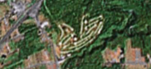
Is it a germ under a microscope or an aerial view of a golf course? Unfortunately, our editor Erik J. Barzeski’s Lake View home course outside Erie, PA does not yet render in high enough resolution to play these games.
Another drawback is that some of the images could have been taken as long as three years ago. So, for example, the new pot bunker installed this year at the first green on my home course doesn’t show up. Some newer courses, like the one Alan Olson reviewed recently (Riverwood National in Otsego, MN) appear only as bare dirt farmland.
Also, photos were taken at all times of the year. So some winter shots of Bermuda grass courses kind of brown out and make fairways difficult to discern. Some courses may even be snow covered.
Google Earth is labeled a beta version and I’m betting it stays a beta for some time as they continue to update specific areas and introduce higher resolution images.
In the Meantime
If you’re lucky to find your course available for an aerial survey, I think you’ll have some fun re-thinking course strategies and measuring your shot distances. I’d be very interested in your feedback and other ideas on how to use Google Earth for golf. So what do you think?
Photo Credits: © 2006 TerraMetrics, © 2006 Europa Technologies, © 2006 Google, © 2006 Sanborn, © 2006 New York GIS

I never thought of this application for Google Earth…I am going to have to give it a try.
Very cool Jack. I wa able to find Tanglewood and use the techniques you were talking about. Unfortunately, part of the Reynolds Course was obscured by clouds…but it’s still a very neat technique and you could create some interesting yardage books.
Psssst, hey Jack…
I have discovered the true value of Google Earth: It provides one the ideal access roads (and parking spots) to enjoy some late evening play on otherwise inaccessible private course gems.
PMDFA6
I’m not hitting as many 300 yard drives as I thought 😉
I really like learning about all the elevation changes from tee to fairway to green.
Thanks for this discovery. I’ve used Google Earth in the past, but didn’t realize it had a measurement tool.
BTW, I’ve integrated Google Maps to show local course locations at golfslo.com. I’ll have to see if I can integrate Google Earth so website visitors can get to these features more easily.
Yes, Google Earth is an amazing tool for looking at courses. I kept going on an searching for the ones I know about, then I found this site that’s already done it for us. http://www.eyespygolf.com
I don’t think they have that measurement tool but perhaps you can do it yourself, or tell them to add it. Looks like they have 16,000 US courses…very cool.
Your readers might like to know we’ve added a comprehensive mapping of Augusta National, just in time for The Masters. We’ll also be adding a video fly over shortly for those without Google Earth. Download it.
We’re planning to do a lot more courses but if any readers of The Sand Trap have mapped their local or favorite courses, feel free to send to us and we’ll add to the site.
Here’s to a fantastic weekend glued to the TV!